It has been awhile since I posted, mainly because I have not been flying very much. I came across this app that helps people visualize what it would be like to be in a commercial airplane crash. It would be interesting to see someone create this for private aircraft as well.
http://lifehacker.com/prepare-for-impact-shows-you-how-to-survive-a-plane-cra-1765791729
Friday, March 25, 2016
Sunday, July 5, 2015
Aero Glass
It has been forever since I last posted. Have not been doing much interesting flying lately but have been at least staying current. I'm in the market for a new ADS-B device and in looking around saw these new "augmented reality" glasses concept for pilots from Aero Glass (no word on when the actual product will be released). Looks very cool, perhaps a bit too much "augmentation" but I would guess can be configured to your liking. Reminds me of Google glasses. See for yourselves in the video.
from the company:
Augmented Reality meets Synthetic Vision and is the next big step in safety and information for pilots. Aero Glass provides a unique turnkey solution addressing pilots' need to properly visualize terrain, navigation, traffic (ADS-B), instrument, weather, and airspace information with access to vital safety procedures and protocols, without the requirement of inspecting instruments, phone or iPad. Using Google Glass, Epson and other Head-Mounted Displays, Aero Glass is the first to bring Augmented Reality to pilots providing an unparalleled 3D, 360° experience in the cockpit. When combined with an iLevil, the Glasses have access to reliable GPS, ADS-B weather and Traffic, and the un-matched AHRS reliability that Levil provides. When using the iLevil AHRS, Aero Glass will display the actual attitude of your airplane, versus the attitude of your head (when using internal gyros of the glasses). For more information Go to http://glass.aero
Friday, August 8, 2014
FltPlan Go app now iPhone compatible as well

More and more of our users are relying on our free FltPlan Go apps for iPad and Android. Now we’ve got iPhone users covered, too, with our new FltPlan Go for iPhone app. FltPlan Go for iPhone has most of the same functionality as our tablet apps, all in your pocket. Look for features such as:
- Rubber banding for flight planning
- Ability to create and edit routes offline
- Breadcrumbs - leaves a trail of where you have been on the screen
- XM - WX capabilities from Baron Weather
- Geo-Referenced Taxi Charts
- Geo-Referenced IFR Approach Charts
- Helicopter Routes, TAC Charts
- Graphical SUAs (Special Use Airspace) for offline use
- Multiple binders for easy access to the info you need
- Ability to save notes and highlight on multiple Approach Charts
- Enhanced FBO information
- Current fuel prices
Like our other apps, FltPlan Go for iPhone is free. Download it from iTunes App Store.
Monday, July 14, 2014
Amelia Earhart becomes first woman to circumnavigate the globe by plane

Saturday, January 11, 2014
Approach like a Pro

Notice Number: NOTC4840
Reduce your risks during approach and landing by using a Stabilized Approach to the runway. That's what the air carriers do. You'll have to develop your own rules for your Stabilized Approach depending on your aircraft. Here are some ideas to get started:
- Stabilized Approach begins at 500 feet AGL
- Approach airspeed is +5 -0
- Only small changes in heading/pitch are necessary to stay on flight path
- Aircraft is in the landing configuration
Once you've decided on your Stabilized Approach Rules make them part of your personal minimums. If you find you are breaking a rule it's time go GO AROUND …
Tom Turner also covered stabilized approaches nicely in this AvWeb article:
http://www.avweb.com/news/leadingedge/leading_edge_23_stabilized_approaches_199047-1.html
Wednesday, November 27, 2013
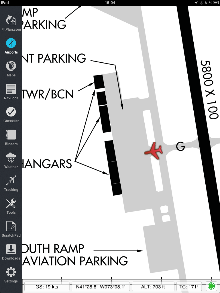
Geo-Referenced Approach Charts Free on FltPlan Go
Passing on this huge announcement from FltPlan.com. They are now offering free geo-referenced approach plates and taxi diagrams! I have used FltPlan Go in the past, and while they have some usability work to go, at this point it could be considered a viable replacement for Foreflight.


========================================
Geo-Referenced Approach Charts Free on FltPlan Go
In addition to our Geo-Referenced Taxi Charts, FltPlan Go now has Geo-Referenced Approach Charts for the entire U.S.
Our apps and our digital charts are completely free.
To download FltPlan Go, go to Apple's iTunes Store.
https://itunes.apple.com/us/app/fltplan-go/id694832363?mt=8
Wednesday, November 13, 2013
Time lapse thunderstorm
Posting this amazing video of a "supercell" thunderstorm captured by Mike Oblinski (@MikeOlbinski). A supercell harbors a mesocyclone, a rising column of air surrounded by drafts of falling air. You can see the air being sucked up in the middle of the storm.
A supercell near Booker, Texas from Mike Olbinski on Vimeo.
A supercell near Booker, Texas from Mike Olbinski on Vimeo.
Subscribe to:
Posts (Atom)